
What Exactly Is El Niño?
Translated from Spanish as “the little boy,” El Niño is a completely natural climate pattern that starts in the Pacific Ocean but ripples across global weather systems—heavily impacting the Indian subcontinent.
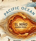
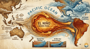
In a normal year, warm ocean water piles up near Asia. But during an El Niño phase, these warm waters shift backward, moving east toward South America and leaving the ocean surface much warmer than usual.
How Does It Form?
It all comes down to the trade winds, the steady winds that usually blow from east to west along the equator. El Niño kicks off when these winds weaken or completely reverse direction.
| Ocean State | Normal Conditions | During El Niño |
| Wind Movement | Winds push warm surface water from South America toward Asia. | Trade winds weaken or reverse direction. |
| Water Temperature | Deep, cold water rises near South America (a process called upwelling). | Warm water sloshes back east toward South America. |
| Nutrient Cycle | Upwelling brings nutrient-rich cold water to the surface. | Upwelling stops, trapping the cold water deep below. |
What Causes It?
El Niño is one half of a larger natural cycle known as ENSO (El Niño-Southern Oscillation), which typically resets every two to seven years. While scientists still don’t know the exact trigger behind the shift, we know it isn’t new. In fact, South American fishermen first documented these unusually warm ocean currents all the way back in the 1600s.
The Impact on the Indian Subcontinent
Even though the core action happens thousands of miles away in the Pacific, the atmospheric domino effect hits the Indian subcontinent hard:
- Weakened Monsoons: It disrupts wind patterns, leading to significantly less rainfall.
- Frequent Droughts: Historically, most India’s major drought years have lined up directly with El Niño cycles.
- Agricultural Stress: Less rain means lower crop yields, which quickly escalates into food security issues and economic strain for farmers.
- Intense Heatwaves: It frequently triggers spiking temperatures and severe heatwaves, posing a genuine threat to public health if cities aren’t prepared.
- Marine Disruptions: Because the normal flow of cold, nutrient-rich water stalls, marine life and local fishing industries suffer heavily.
Smart Ways to Prepare
We can’t stop El Niño, but we can outsmart it. Preparing ahead of time makes all the difference:
- Smart Farming: Shifting toward drought-resistant crops that require less water, and adjusting planting schedules based on early monsoon forecasts.
- Water Management: Scaling up rainwater harvesting during good seasons, building more community ponds, and upgrading local well networks.
- Community & Policy: Relying on early government weather warnings to plan ahead, and setting up village-level water-sharing agreements to manage shortages fairly.
These episodes usually lock in for 9 to 12 months, though they can occasionally drag on for years. With global weather agencies confirming that El Niño conditions are strengthening for 2026, the subcontinent may face a weaker monsoon season this year. It is a natural phenomenon we can’t control but by managing our water and farms wisely, we can easily protect our lives and livelihoods from its worst effects.